3D Rendering Landscape
Servicess
Species-accurate. Seasonally calibrated. Topographically correct.
3D landscape rendering is the process of creating realistic digital visualizations of outdoor spaces before they are built. Using specialized 3D modeling and rendering software, designers can present gardens, parks, residential yards, commercial landscapes, and public spaces with lifelike details, helping clients visualize the finished project. A 3D Rendering Landscape tells you what species go where. It tells you nothing about how the garden smells in May, how a hornbeam hedge filters afternoon light in October, or how a courtyard feels when the water feature is running and the perennial borders are in full summer flush. That gap between the technical document and the lived experience is where landscape visualization does its most important work.
RenderLand resolves this tension. Not with decorative greenery composited over a building render, but with species-accurate, seasonally calibrated, topographically correct landscape CGI built directly from your planting data and site survey information.
RenderLand delivers 3D Rendering Landscape services across the United States, covering residential estates, resort grounds, master plans, and LVIA submissions. National coverage. Species-accurate. Seasonally calibrated from day one.
What is 3D Rendering Landscape?
3D rendering landscape is the process of creating realistic digital visualizations of outdoor spaces before they are built. Using specialized 3D modeling and rendering software, designers can present gardens, parks, residential yards, commercial landscapes, and public spaces with lifelike details, helping clients visualize the finished project.
3D rendering landscape translates the biological and spatial intelligence locked inside a planting schedule into an image that any person, regardless of technical training, can immediately read, feel, and respond to. It shows what the scheme will look like on a Tuesday morning in late September when the Japanese maples are turning, not just at the idealized peak of a summer brochure shoot.
The service output is clear: a photorealistic computer-generated image of a designed outdoor environment, produced from site survey data, landscape plans, planting schedules, and material specifications. It is worth being precise about what this is not.
A landscape concept sketch communicates intent, not reality. A landscape photograph shows the existing site, not the proposal. A building exterior render with greenery added in post approximates landscape quality without species accuracy or seasonal truth. 3d landscape rendering visualization is none of these things. It is a purpose-built production process for outdoor environments specifically.
Why Landscape Rendering Does What No Other Medium Can
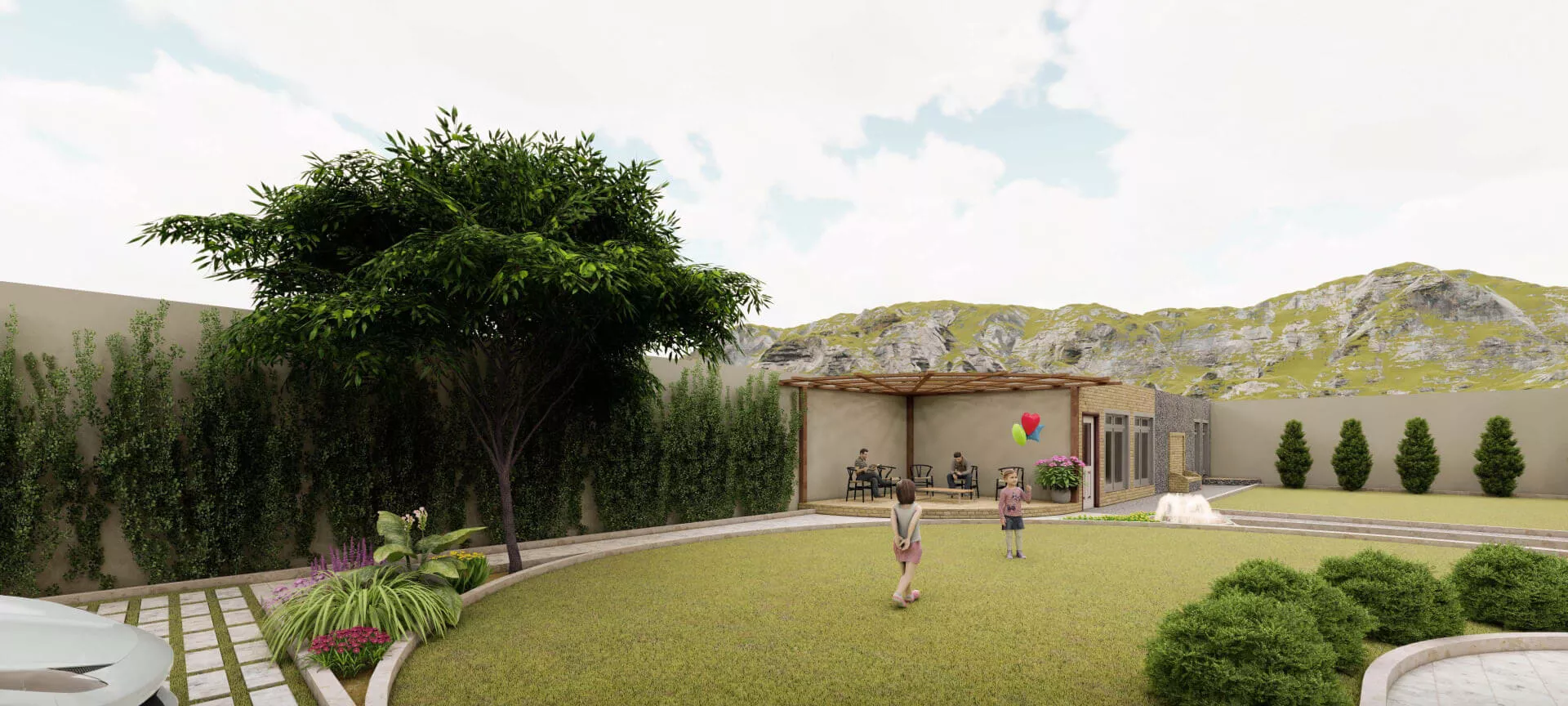
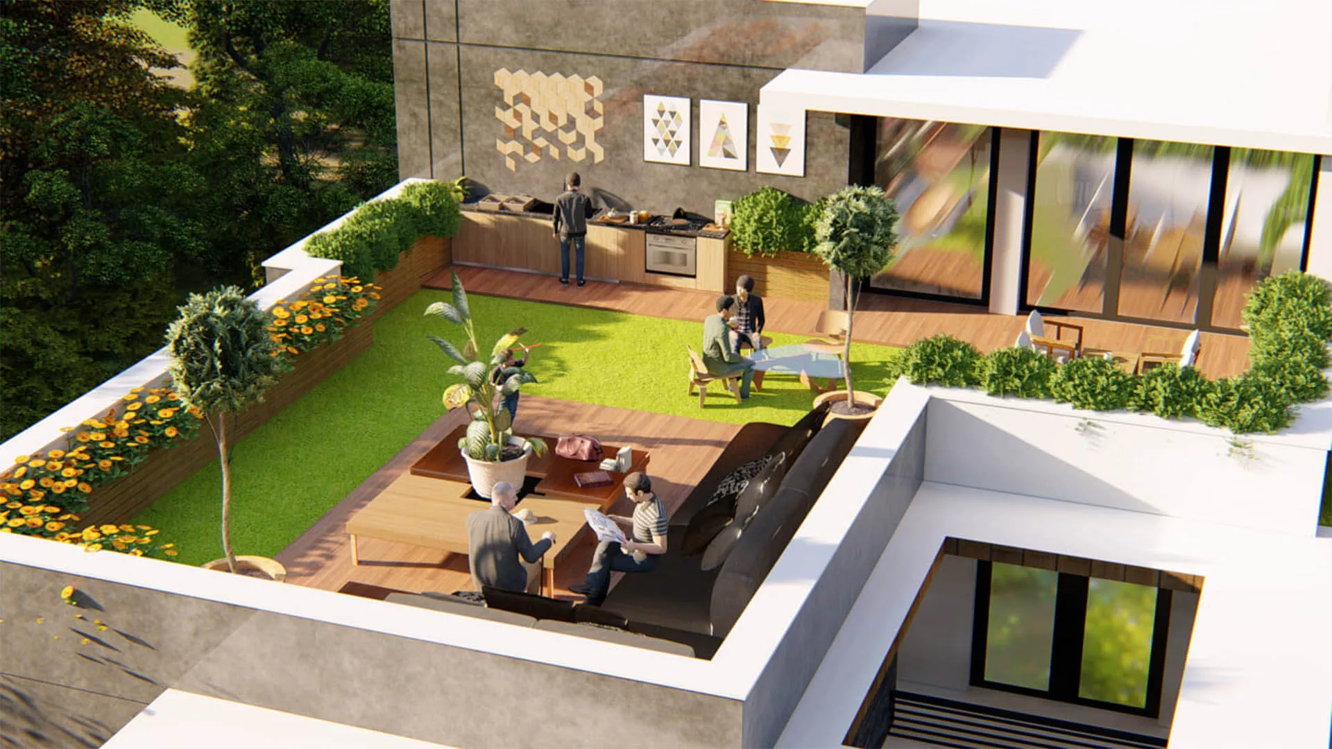
A single 3D rendering landscape scene can be rendered in spring blossom, summer full canopy, autumn color, and winter bare-branch structure. No other visualization medium, photography, physical model, mood board, or diagram, can show the same design across four seasonal states from consistent viewpoints.
For a landscape architect presenting to a client who expressed concern about winter interest, this is the sign-off tool. For a developer marketing a garden apartment, the summer render sells the lifestyle and the autumn render justifies the premium.
Benefits of 3D Rendering Landscape
With RenderLand
The differentiation argument here is not about rendering quality or process efficiency. Any competent studio can deliver those. It is about 3d rendering landscape literacy. RenderLand can read a planting schedule. That means the studio knows the difference between a species selected for winter interest and one selected for summer screening, between a rain garden that needs to look naturalistic and a formal parterre that needs geometric precision, between a planting plan where privacy is the priority and one where biodiversity is.
We Read the Planting Plan — We Don't Approximate It
A studio without landscape literacy renders a planting plan as a collection of generic tree and shrub shapes. A studio with it renders a planting plan as the specific designed landscape the landscape architect intended: correct species, correct seasonal state, correct scale, correct density. The difference is visible in the first draft.
USDA hardiness zone cross-referencing, phenological timing accuracy, and Forest Pack density calibration that produces a planted border looking established rather than just placed — these are the production details that separate a species-accurate landscape render from a generic green scene.
LVIA-Grade Accuracy Is Built into the Process, Not Added at the End
Planning-grade landscape renders require terrain accuracy, correct HDRI sun calibration, and species-representative vegetation mass from the beginning of the production process. Compositing these elements in post-production introduces the errors that cause planning authority queries.
RenderLand's terrain-first, species-accurate workflow means the first draft is LVIA-compliant, not the fifth revision. For landscape architects and planning consultants working to submission deadlines, this production discipline is not a nice-to-have. It is the difference between a single-round submission and a multi-round resubmission process.
The Scene Delivered Is an Asset, Not a File
The designed landscape will evolve. Phase 1 planting will be revised for Phase 2. A seasonal marketing campaign will want a winter render six months after the summer launch. A planning resubmission will need revised screening heights after a committee comment.
The 3D scene and vegetation asset library delivered by RenderLand on project handover is a reusable production asset, not a single-use render file. For developers and landscape architects with multi-phase projects, this has direct commercial value that compounds over the life of the scheme.
Landscape literacy is the differentiator. RenderLand can read a planting schedule — the studio knows the difference between a species selected for winter interest and one selected for summer screening, between a rain garden that needs to look naturalistic and a formal parterre that needs geometric precision, between a planting plan where privacy is the priority and one where biodiversity is.
The Business Case for Landscape Rendering Visualization
Outdoor space is chronically undervisualized relative to its commercial value. A residential developer will commission photorealistic interior renders of every kitchen and bathroom, then show the garden as a pale green rectangle on a site plan. A hospitality investor will receive a detailed fly-through of the hotel lobby and guest rooms, then evaluate the pool terrace from an AutoCAD line drawing. A 3d rendering landscape architect will produce a meticulously designed planting scheme and present it on a technical plan that no client can emotionally engage with.
This is not a minor gap. The landscape is often the premium. The pool terrace that justifies the penthouse price. The garden that sells the family home over the identical unit next door. The resort grounds that close the investment round.
The visualization budget should reflect that commercial reality. Most of the time, it does not.
The Garden Is Selling the Apartment — Developers Who Know This Win Pre-Sales Faster
Residential developers routinely underinvest in landscape visualization relative to interior renders, despite outdoor amenity space being a primary pricing driver for family homes, garden apartments, and luxury residential schemes. A photorealistic render of a private garden terrace, a communal courtyard, or a rooftop garden communicates the outdoor lifestyle that buyers are actually purchasing.
This is a marketing arbitrage opportunity. Most developers are not doing it well, which means the ones who are stand out sharply in pre-sale campaigns. Before site completion, no site photography is possible. A 3d rendering landscape render is the only credible outdoor lifestyle asset available at launch. Developers who use it close pre-sales faster and with stronger pricing on outdoor-facing units.
The Pool Deck Closes the Investment Round — What Hospitality Investors Actually Evaluate
Resort and hotel investors are evaluating outdoor amenity as a revenue center, not just a backdrop. Pool deck food and beverage, garden event space, outdoor dining, spa terrace — these are revenue lines, not landscaping decisions. When an investment deck shows a site plan where a photorealistic resort landscape render should be, the investor is being asked to fund an experience they cannot see.
Hospitality capital is emotional as well as analytical. The outdoor environment is where brand atmosphere lives. A twilight render of a resort pool terrace communicates quality tier and guest experience in a way that no room count or RevPAR projection can replicate. The render does not replace the financial model. It makes the financial model believable.
The Planning Board Approved the Scheme Because They Could See It — LVIA and the Visual Evidence Standard
US planning authorities, environmental agencies, and HOA architectural review panels are increasing their visual evidence requirements for landscape proposals. Generic computer renders calibrated to no particular site, season, or vegetation species do not satisfy Landscape and Visual Impact Assessment standards.
LVIA-grade renders with correct HDRI sun position, accurate vegetation mass, and site-specific topography are regulatory compliance tools as much as marketing assets. They reduce resubmission cycles and appeal risk. The specific regulatory frameworks this applies to include:
RenderLand's production process is built to meet these standards from the first draft.
A 3D landscape rendering is one of the most effective visualization investments for residential, commercial, and public outdoor projects. RenderLand delivers photorealistic landscape renderings that showcase planting, hardscape, lighting, water features, and site layouts—optimized for client presentations, planning approvals, marketing campaigns, and real estate development.
The Production Process OF 3D Rendering Landscape
3D Rendering Landscape production involves biological and ecological knowledge that architecture-focused studios typically do not have. Reading a planting schedule, verifying USDA hardiness zone accuracy, selecting the correct asset for a Betula utilis jacquemontii versus a Betula pendula, and building seasonal foliage states from a single scene base is not a software operation. It is a landscape design literacy operation. Every step of the RenderLand process reflects that.
Reading the Brief Like a Landscape Architect, Not a 3D Artist
The client submits site and landscape design data: AutoCAD DWG/DXF, Revit .rvt, SketchUp .skp, PDF plans, planting schedules, and site photography. RenderLand reads the planting schedule for species intent, cross-references USDA hardiness zone data for seasonal accuracy, identifies the hardscape-to-softscape balance the designer is proposing, and flags any brief ambiguities before production begins.
At this stage, RenderLand confirms: the views and seasonal variants required, species preferences and climate zone, material specifications, and output format. Early-stage concept plans are accepted. A finalized planting specification is not a prerequisite for beginning work.
Building the Ground Before Placing a Single Plant
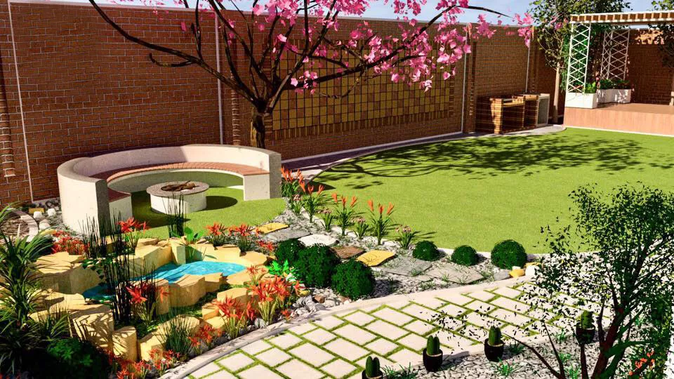
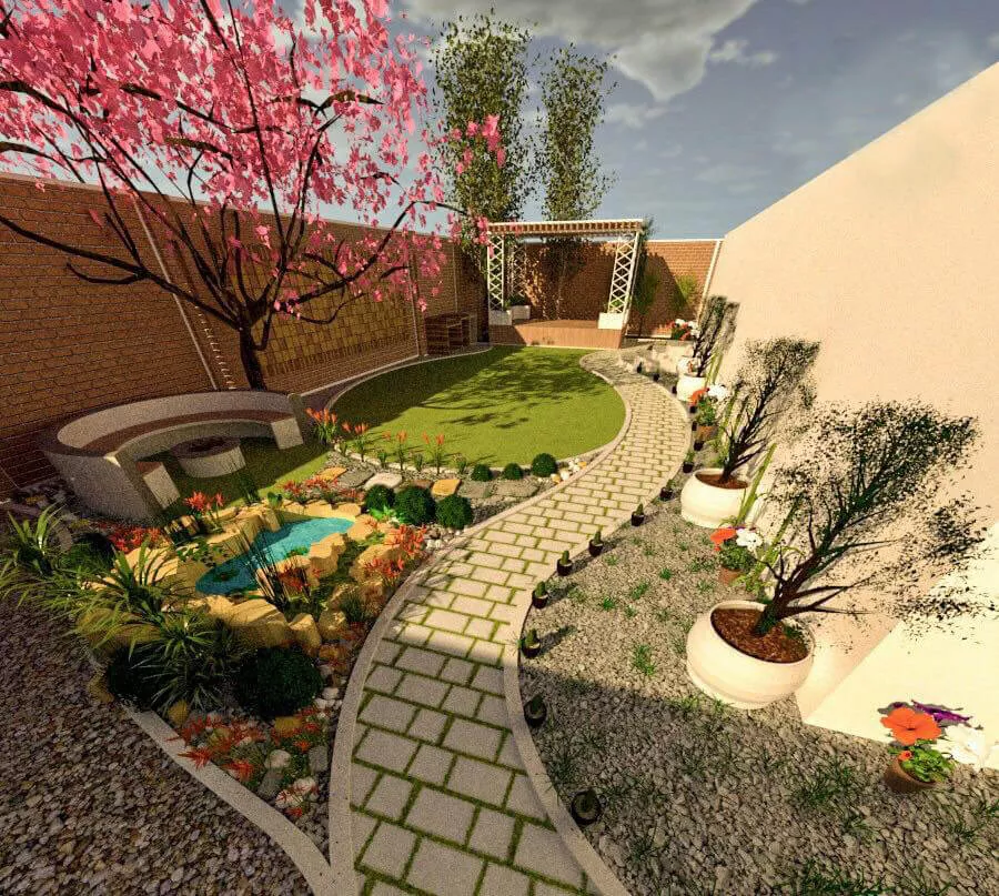
Site terrain is constructed from survey data, grading plans, LiDAR, or drone orthophoto inputs. Retaining walls, grade changes, terraces, steps, and boundary elements are modeled to grading plan accuracy. Existing trees scheduled for retention are modeled or imported. A terrain draft is delivered and approved before vegetation build begins.
Most studios skip this step. They build on flat ground and suggest slopes through post-production texture work. RenderLand's terrain-first approach means shadow angles are correct, drainage logic reads visually, and retaining walls sit at the right height relative to the planted beds above them. That accuracy matters at LVIA submission stage.
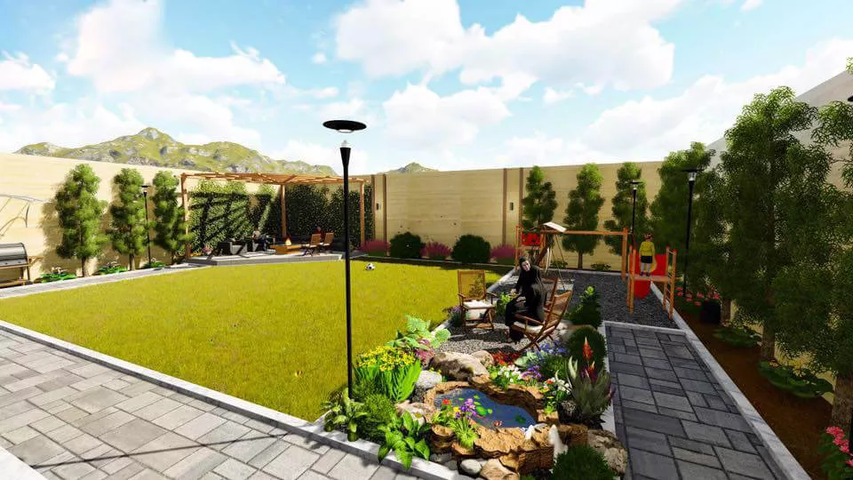
Placing Plants Like a Landscape Contractor, at Scale and in Season
Species-accurate trees, shrubs, ground cover, and lawn are placed from the planting plan using Forest Pack, GrowFX, and SpeedTree for procedurally correct, non-repetitive distribution at designed density. Seasonal foliage states are built from a single scene base across spring, summer, autumn, and winter.
Hardscape materials are applied: paving, decking, pool finishes, gravel, timber. Water features, outdoor furniture, lighting, and lifestyle entourage are placed per brief. The phrase 'at scale' matters here. A common failure in landscape CGI is trees that look correct as isolated specimens but wrong at landscape scale, too uniform, too evenly spaced, too dense or sparse. Procedural scatter tools solve this problem.
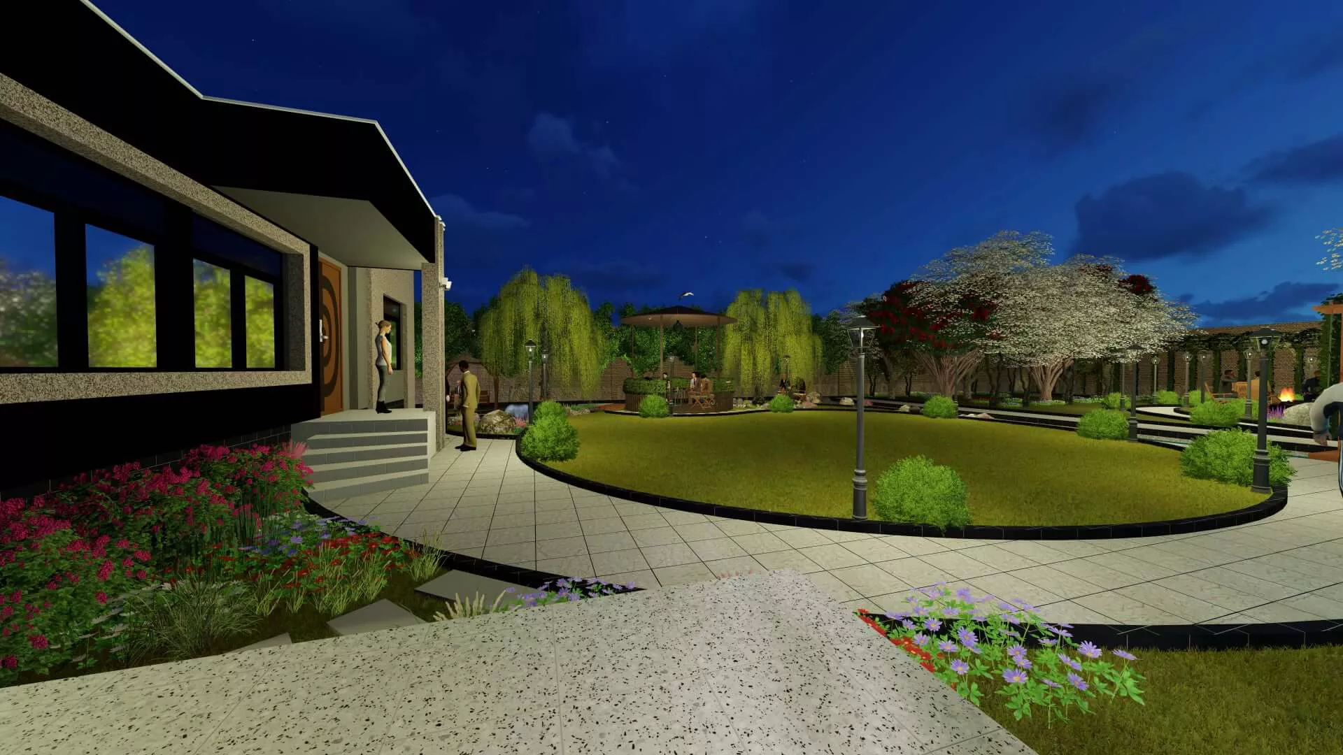
Setting the Sun, the Season, and the Atmosphere
HDRI sky is selected and sun position calibrated to the project's GPS coordinates, agreed date, and time of day. This produces geographically accurate shadow angles, not a generic midday sun. IES photometric profiles are applied to all artificial lighting: pathway bollards, uplighting for feature trees, pool lighting, festoon strings.
Atmospheric effects are set per brief: morning mist, golden-hour warmth, overcast diffuse light, twilight blue-hour, wet-surface reflections. Multiple scenario rigs are built simultaneously where day and night are both in scope.
This step is where a landscape render acquires its emotional register. The difference between a clinical daylight verification render and a golden-hour lifestyle image that makes someone want to sit in the garden starts here.
Rendering at 4K or 8K and Building the Atmosphere in Post
Scenes are processed through a GPU render farm at 4K standard output or 8K for print, hoarding, and LVIA submission. Multi-pass compositing follows: beauty, shadow, ambient occlusion, Z-depth, and reflection passes layered in Photoshop or Nuke. Atmospheric depth layers, sky enhancement, lifestyle entourage additions, and lens depth-of-field are applied in post.
Color grading in DaVinci Resolve produces the final visual register: warm residential lifestyle, naturalistic ecological, cool contemporary commercial, or resort luxe. The first proof is delivered via a secure review link.
Delivering a Scene That Can Grow With the Project
Final delivery formats include JPEG and PNG for web, listing, and social; TIFF and PDF at 300 DPI minimum for print and planning submission; and MP4 for animated sequences where in scope. But the delivery structure is designed for landscape specifically.
Unlike a building, a landscape design evolves across scheme phases, planning iterations, and seasonal marketing campaigns. Raw scene files and vegetation asset libraries are available on handover because a landscape architect may need to re-render the same scheme with revised planting in Phase 2, or a developer may want an autumn version six months after the summer campaign launched.
RenderLand's 3D Landscape Rendering Technical Standards
The primary differentiators in landscape visualization are not rendering engine choice or GPU render farm capacity. Any competent studio can run V-Ray on a fast machine. The differentiators are biological and ecological: species accuracy, seasonal phenological correctness, terrain fidelity, and LVIA-grade sun position calibration. Those are the standards RenderLand is built around.
Species Accuracy Isn't a Style Choice — It's a Professional Standard
Most architectural visualization studios render landscape using generic tree and shrub assets. Rounded green canopies that read as 'tree' without communicating species, growth habit, seasonal behavior, or scale relationship. A landscape architect who has specified a multi-stem Amelanchier lamarckii as a focal point receives a render showing a generic oval canopy. The designed planting intent is invisible.
RenderLand's vegetation library is built around species-correct assets. Crown form, branching structure, leaf shape, seasonal color, and canopy density are all calibrated to the named species.
A rendered Liquidambar styraciflua turns red in autumn rather than staying generically green, because the scene is built from species data, not guesswork.
Crown form, branching structure, and leaf shape calibrated to named species.
Procedurally correct, non-repetitive distribution at designed planting density.
Seasonal foliage states matched to species phenology, not generic seasonal presets.
Every planting decision verified against climate zone data for seasonal accuracy.
Light transmission through foliage rendered physically, not approximated with flat textures.
The Terrain Is the Foundation — Why Flat Ground Ruins Landscape Renders
Terrain modeling accuracy is the structural foundation of a credible landscape render. A landscape render built on a flat ground plane with slope implied by a texture gradient fails in three ways. Shadow angles are wrong for a graded site. Retaining walls appear to float rather than retain. The spatial relationship between terraced levels is impossible to read.
RenderLand constructs terrain from site survey data, AutoCAD Civil 3D grading plans, LiDAR point cloud inputs, and drone orthophoto composites. The ground under the planting is the actual ground.
For LVIA submissions, this matters directly. A planning authority reviewing a visual impact assessment render will notice when the site topography does not match the planning drawings.
Terrain constructed from real survey inputs, not estimated or approximated ground planes.
Grading plan accuracy translated directly into the 3D scene geometry.
High-resolution terrain data used where survey accuracy is critical for LVIA compliance.
Aerial survey data integrated for existing site context and vegetation retention accuracy.
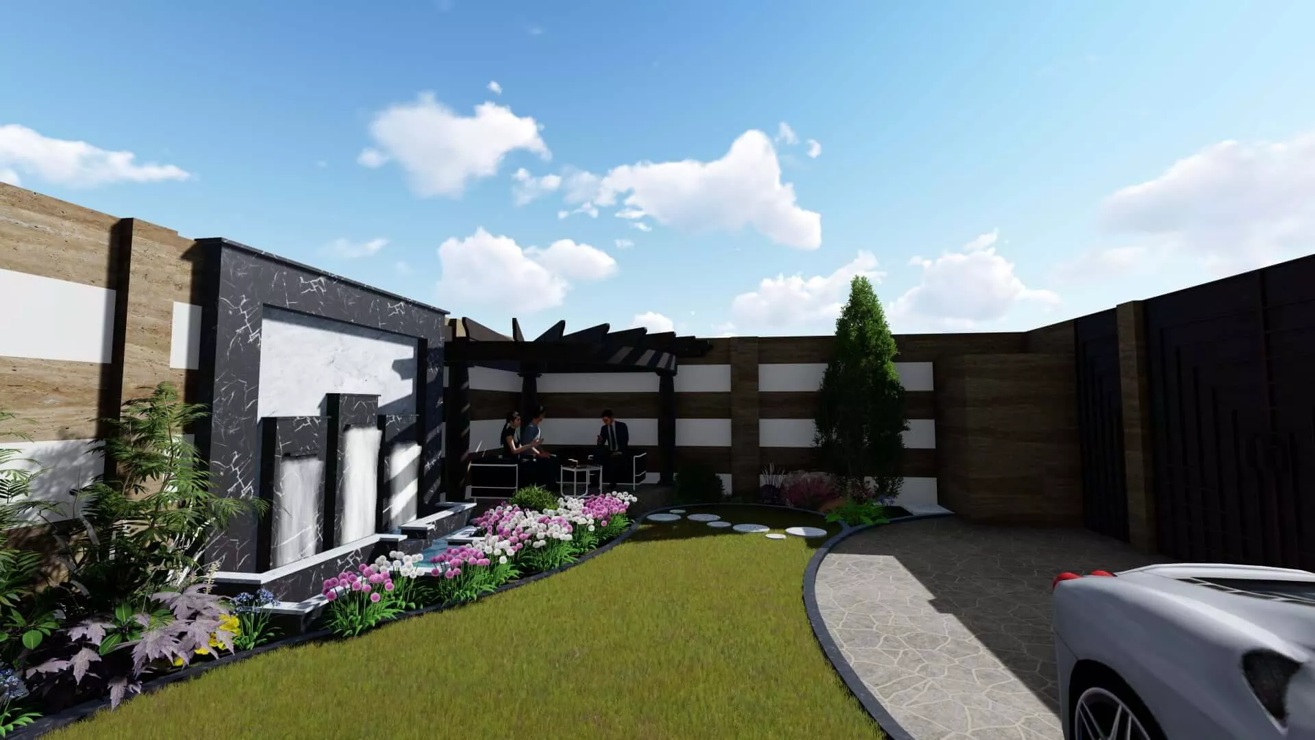
Atmosphere Is Not a Filter — It Is an Argument
A landscape render is not just a spatial document. It is an argument for the value of being outside in a specific place at a specific moment. Morning mist through a woodland garden communicates a sensory experience that a noon daylight render of the same scene cannot. A twilight resort pool render communicates guest experience atmosphere that a technical assessment render never will. Golden-hour light raking across a perennial border makes a client feel what a garden designer spent months creating.
Volumetric fog and mist rendering, golden-hour garden CGI, HDRI sky and sun position accuracy, IES outdoor light profile rendering, wet versus dry surface material simulation, and sunset sky reflection in water are not post-production effects. They are the visual language of landscape quality, and they are built into the scene from step four of the production process.
Sun position calibrated to GPS coordinates, agreed date, and time of day. Geographically accurate shadow angles.
Photometric profiles applied to pathway bollards, feature tree uplighting, pool lighting, and festoon strings.
Morning mist, golden-hour warmth, overcast diffuse light, and twilight blue-hour built into the scene geometry.
Surface reflectivity and material response modeled for rain, dew, and post-precipitation conditions.
Pool surfaces, water features, and reflective ground planes respond correctly to sky and atmospheric conditions.
A 3D landscape rendering is one of the most effective visualization investments for residential, commercial, and public outdoor projects. RenderLand delivers photorealistic landscape renderings that showcase planting, hardscape, lighting, water features, and site layouts—optimized for client presentations, planning approvals, marketing campaigns, and real estate development.
Who 3D Rendering Landscape Service Is For?
The three buyer segments for 3d rendering landscape visualization have genuinely different professional motivations, anxieties, and success metrics. The copy below speaks directly to each of them, because the service addresses each one differently.
Stop Losing Pitches You Should Be Winning
The landscape architecture market in the United States is increasingly competing on visual presentation quality, not just design quality. Selection committees and institutional clients make shortlisting decisions in the first sixty seconds of looking at a competition board. A photorealistic landscape render communicates design quality faster than any combination of drawings, diagrams, and mood boards.
Landscape architects are routinely shortlisted against architecture-led teams whose visualization budgets are significantly higher. They lose not because their design is weaker but because their representation is.
RenderLand's landscape renders function as a competitive equalization tool. Additional professional benefits include faster client sign-off on planting and materials, fewer late-stage scheme changes, and a portfolio asset that works across award submissions, PR, and firm credentials.
The Outdoor Amenity Is a Revenue Line, Not a Backdrop
Outdoor amenity space, private garden allocation, pool terrace, courtyard garden, rooftop amenity, commands a measurable premium per square foot in residential and mixed-use schemes. A photorealistic landscape render is the marketing asset that communicates that premium to a buyer who cannot visit the site.
Most developer marketing campaigns underinvest in landscape visualization and then underperform on outdoor amenity pricing. The render is a revenue protection investment.
A summer pool terrace render in a pre-launch brochure is not a production cost. It is the asset that closes the sale on the garden apartment at full asking price.
Making the Invisible Legible
This audience is not making an investment or marketing decision. They are making an approval decision on behalf of a community or regulatory body. Their anxiety is approving something they do not fully understand, then being held responsible when it looks different from what they were told.
A photorealistic landscape render removes this anxiety. It shows decision-makers exactly what they are approving, at the correct scale, in the correct season, from the relevant viewpoint.
RenderLand's LVIA-grade accuracy is the specific capability that makes this possible. Not a decorative render, but evidential visualization built to the standard that planning authorities and HOA review panels require.
Landscape Visualization Problems That Cost Clients Real Money
The problems below are specific to the landscape discipline. Each one has a real commercial consequence. Each one has a direct resolution through professional 3d rendering landscape.
"I've Shown Them the Planting Plan Three Times and They Still Don't Know What to Approve"
This is the landscape architect's most common sign-off problem, and it has a specific professional cost: revision cycles driven not by design dissatisfaction but by client inability to read a technical drawing. The species-accurate, seasonally correct 3D landscape render shows the client exactly what they are approving at human scale, in the correct light, with the correct plants. Interpretive ambiguity disappears. A client who can see the garden approves it.
"The Client Approved the Summer Version — Now They're Unhappy with What January Looks Like"
This problem is unique to landscape. A client who approved a scheme based on a summer render and is now unhappy with bare-branch winter structure was never shown the winter version. The four-season render set produced from a single base scene resolves this completely. Spring blossom, summer full canopy, autumn color, and winter bare-branch structure, all from the same camera positions. The client approves the full seasonal picture before procurement begins.
"The HOA Rejected the Submission — Said They Couldn't Understand the Visual Impact"
HOA architectural review boards in the United States reject landscaping proposals for precisely this reason, with significant cost consequences: resubmission fees, programme delays, and in some cases complete scheme redesigns. A photorealistic render showing the proposed planting from the street, from neighboring properties, and at the site boundary gives the HOA committee the visual evidence it needs to approve with confidence.
"Our Pre-Sale Brochure Has a Green Rectangle Where the Garden Should Be"
The outdoor space is often the primary differentiator for the unit, and it is invisible in the marketing. A pale green shape on a floor plan communicates nothing about the private terrace or communal garden that the buyer is actually purchasing. A photorealistic garden or terrace render positions outdoor living as the headline asset in the campaign, not the afterthought at the back of the brochure.
"The Investor Deck Has a Site Plan Where the Pool Terrace Should Be"
Resort and hospitality developers presenting to capital partners know this situation. The investment deck is strong on room count, food and beverage projections, and RevPAR modeling, and weak on the guest experience that justifies all of those numbers. A twilight render of the pool terrace or garden restaurant communicates atmosphere, quality tier, and commercial viability in a way that financial projections simply cannot.
"We Lost the Competition — Our Design Was Better, Their Presentation Was"
This is the landscape architect's most professionally painful loss: a scheme they know is stronger, evaluated against a competitor's weaker design rendered to a higher visual standard. Selection committees make shortlisting decisions on what they see first. A photorealistic competition board render communicates design quality in the first sixty seconds. A technical drawing set requires ten minutes of explanation that a selection committee often does not have.
"The Planning Authority Came Back with a Request for More Visual Evidence"
A request for additional visual information from a US planning authority or environmental agency at LVIA assessment stage delays an application by weeks and costs both programme time and professional fees. An HDRI-calibrated, topographically accurate, species-correct landscape render submitted with the original application is the visual evidence standard that prevents this request. RenderLand's LVIA-grade production process is built to satisfy the requirement before it is made.
"The Golf Course Routing Diagram Doesn't Show Anyone What It's Like to Play the Hole"
A routing plan shows where the holes go. It communicates nothing about the experience of standing on the 7th tee with a 185-yard carry over a bunker-flanked approach to a green framed by maturing specimen oaks. A 3D golf course hole render communicates that experience to investors, club members, and planning authorities before a divot is cut. For golf course designers, sports facility developers, and recreational planners, this is the communication gap that landscape CGI closes.
Industries For 3D Rendering Landscape
The 3d rendering landscape serves a different purpose in every industry below. The format, the viewpoint, the seasonal state, and the level of ecological detail all shift depending on whether the output is for a marketing campaign, a planning submission, or a capital raise. RenderLand understands those differences and produces output calibrated to the specific decision-making context.
A 3D landscape rendering is one of the most effective visualization investments for residential, commercial, and public outdoor projects. RenderLand delivers photorealistic landscape renderings that showcase planting, hardscape, lighting, water features, and site layouts—optimized for client presentations, planning approvals, marketing campaigns, and real estate development.
RenderLand's 3D Rendering Landscape Technology
The technology section on 3d rendering landscape has a different character from the equivalent sections on interior rendering or walkthrough animation pages. The key distinction is the vegetation toolchain, which represents a specialized production capability that does not appear in general architectural visualization workflows. That is where this section leads.
The Vegetation Toolchain — Why Generic 3D Studios Can't Match This
Forest Pack from iToo Software, GrowFX, SpeedTree, Maxtree plant models, VIZPARK plant assets, and Quixel Megascans ground textures form the specialist toolchain that makes species-accurate, procedurally distributed, seasonally correct landscape rendering possible.
Forest Pack produces non-repetitive, density-controlled plant scatter at landscape scale. GrowFX generates growth-accurate branching and foliage structure for individual specimen trees. SpeedTree provides species-correct high-fidelity tree models. Maxtree and VIZPARK supply the species library breadth for planting-plan-accurate asset selection. This is the toolchain that separates a studio with genuine landscape rendering capability from one compositing stock tree photographs over a building render.
Terrain and Site Data — From LiDAR to Landscape
AutoCAD Civil 3D handles grading plan data. Global Mapper processes GIS terrain. LiDAR point cloud processing and drone orthophoto import enable topographically accurate terrain modeling from the actual site data. USDA plant hardiness zone references are cross-referenced for species selection accuracy throughout.
These tools make the difference between a render built on the actual site topography and one built on a flat plane with a texture gradient. For LVIA submissions and planning authority review, that difference is the difference between a compliant document and a revise-and-resubmit request.
Rendering Engines, Post-Production, and Cloud Infrastructure
V-Ray, Corona Renderer, Lumion, D5 Render, Twinmotion, Enscape, Octane, and Unreal Engine 5 with Lumen are all available. Engine selection is matched to output type and quality requirement. Post-production runs through Adobe Photoshop, Nuke, DaVinci Resolve, and Adobe After Effects.
GPU render farm capacity is provided via Chaos Cloud, GarageFarm, RebusFarm, Fox Renderfarm, and AWS Deadline Cloud for 4K and 8K output at production timescales. The landscape-specific application is 8K output for hoarding panels and LVIA submission prints, the format that requires render farm infrastructure most urgently. A desktop render at 8K on a complex landscape scene with full vegetation at density is a production timeline problem. The farm solves it.
Photorealistic 3D Rendering Landscape Portfolio
Woodland gardens, resort pool terraces, LVIA submissions, golf course holes, and urban masterplan landscapes rendered to species-accurate, LVIA-grade production standard.


Questions For 3D Rendering Landscape
Every question below comes from a real commissioning conversation. The answers are specific, not templated, because the service is calibrated to professional contexts where generic responses are not useful.
01 How much does a 3D Rendering Landscape cost in the United States?
The price depends on several variables specific to 3D Rendering Landscape work. Site area and complexity matter most: a rear garden render is a different scope from a resort masterplan. The number of views in scope, the seasonal and lighting variants required, the level of species-specific vegetation detail, terrain modeling complexity, and LVIA-grade compositing requirements all affect the final figure.
For orientation: a single-view residential garden render with clear brief and standard planting sits at the lower end of the range. A multi-view, multi-season resort landscape set with terrain modeling and LVIA photomontage compositing sits at the higher end. A project-specific quote is returned within 24 to 48 hours of brief submission.
02 How accurately will you render my specific plant species, and will the seasonal appearance be correct?
RenderLand renders from a species-accurate asset library cross-referenced to USDA hardiness zone and phenological timing data. A Cercidiphyllum japonicum is rendered with its distinctive heart-shaped foliage in summer and with amber and gold foliage color in autumn, reflecting its known seasonal behavior. A Betula utilis jacquemontii is rendered with white bark visible through the canopy in winter rather than as a generic bare deciduous tree.
03 Can you render the same landscape design in all four seasons from consistent viewpoints?
Yes. One base 3D scene produces all four seasonal renders from the same camera positions. Spring blossom, summer full canopy, autumn color, and winter bare-branch structure. The production cost of a four-season set is significantly less than four separate commissions built from scratch.
04 Can you show what the landscape will look like at planting versus five years later?
Yes. Vegetation asset scaling, canopy density adjustment, and ground cover fill are calibrated to represent the designed scheme at immediate post-planting state (small specimens, visible mulch, establishing ground cover) versus established maturity (full canopy, dense borders, screening at designed height).
05 Can you produce LVIA-grade renders for a planning submission or environmental impact assessment?
Yes. LVIA-grade renders require HDRI sky calibrated to the site's GPS coordinates and the agreed assessment season and time of day; terrain built from survey data at grading plan accuracy; vegetation mass and density correct for the named species at the agreed seasonal state; neighboring context modeled to the required assessment radius; and photomontage compositing over site photography where the planning authority requires a photograph-base format.
06 What site data do you need from us to begin, and can you work from early concept sketches?
Accepted formats include AutoCAD DWG/DXF, Revit .rvt, SketchUp .skp, PDF landscape plans, planting schedules, site photography, and survey data. Early-stage concept plans and design intent documents are acceptable starting points. A fully coordinated planting specification is not required to begin production.
Materials that accelerate production include: species list with USDA zone confirmation, material board references, site photography of existing conditions, neighboring context photographs, and any reference renders that indicate the desired visual mood.
07 Can the landscape and building exterior be combined in a single rendered scene?
Yes, and this is the standard commission format for architectural development projects where landscape and building are designed together. The landscape scene and architectural model are integrated: the building sits within the designed grounds, the ground-floor interior is visible through glazing, and the relationship between built form and planted environment reads correctly at every agreed viewpoint.
08 How long does a 3D Rendering Landscape project take from brief to delivery?
A single residential garden render with a clear brief and standard planting typically delivers within five to eight working days. A multi-view, multi-season resort landscape set with terrain modeling and LVIA photomontage compositing requires a longer timeline, typically three to five weeks depending on scope complexity.
The milestone structure specific to landscape includes: terrain draft and approval, vegetation and hardscape scene build, lighting and atmospheric setup, first proof, revision round, and final delivery. Client-side decisions, species confirmation, seasonal variant approval, lighting scenario sign-off, are the primary schedule variables the client controls.
09 Can landscape still renders be developed into animated walkthroughs or fly-throughs later?
Yes. The terrain model, vegetation scene, lighting rigs, and atmospheric setups built for still renders are the same assets used for landscape animation production. Camera paths, animated foliage wind simulation, animated water surfaces, and lifestyle entourage motion are layered onto the existing scene.
10 What are the final file delivery formats, and can the same render be used for print, web, and planning submission?
Yes, all formats derive from the same render pass. Delivery includes: 4K JPEG and PNG for web, listing, and social media; 8K TIFF and PDF at 300 DPI minimum for print brochures, hoarding panels, exhibition display, and planning submission; social media crops at 1:1, 4:5, and 9:16; animated landscape sequences in MP4 H.264/H.265; raw EXR frame sequences for animation compositing handover; and raw scene files and vegetation library for project handover.
Ready to Show the Landscape Before the First Plant Is in the Ground?
The outdoor environment is where the premium lives, where the planning board makes its decision, and where the landscape architect's design intent either communicates or disappears. A planting plan is not enough to close that gap. A 3D Rendering Landscape is.
Submit a project brief and upload a planting plan, site layout, concept sketch, or PDF drawings. Share a reference image or describe the visual register you are after. RenderLand will return a structured scope assessment, a production timeline, and a project-specific price proposal within 24 to 48 business hours.
RenderLand has rendered woodland gardens, resort pool terraces, LVIA submissions, golf course holes, and urban masterplan landscapes across the United States. Each one started with a planting plan and a brief.
Quotes within 24–48 hours. Planting plans, CAD files, concept sketches, and PDF drawings all accepted.